
Objective
Baltic Sea Chart Datum 2000 (BSCD2000) is currently being adopted as unified chart datum by all the countries around the Baltic Sea and also agrees with the national height systems used on land (see Important remarks below for details). BSCD2000 will facilitate effective use of GNSS methods like Galileo, GPS and GLONASS for accurate navigation and hydrographic surveying in the future.
Definition
The Baltic Sea Chart Datum 2000 (BSCD2000) is a geodetic reference system adopted for Baltic Sea hydrographic surveying, hydrographic engineering, nautical charts and publications. It is based on the definitions for the European Vertical Reference System (EVRS) and the European Terrestrial Reference System 1989 (ETRS89). The height reference surface of BSCD2000 is the equipotential surface of the Earth’s gravity field (see detailed remarks no. 2-4 below). The zero level of BSCD2000 is in accordance with the Normaal Amsterdams Peil (NAP). The reference epoch for height and depth changes due to the postglacial land uplift in Fennoscandia is 2000.0. For more detailed information, please refer to the BSCD2000 Specifications document.
Realization and implementation
BSCD2000 is realized by means of the national geodetic coordinates and heights, which agree within the required uncertainty (5 cm standard deviation) according to the BSCD2000 Specifications. The height reference surface is realized by the BSCD2000 height transformation grid, i.e., a geoid model which is fitted to the geodetic reference data and on land harmonized with the national geoid models to the largest extent possible (see Important remarks below for details).
This landing page provides the first release of the BSCD2000 height transformation grid (Realization 2023). It has been accepted by the Chart Datum, Water level and Currents Working Group (CDWCWG) and proposed to the Baltic Sea Hydrographic Commission (BSHC) to be adopted at the 29th BSHC Conference in September 2024.
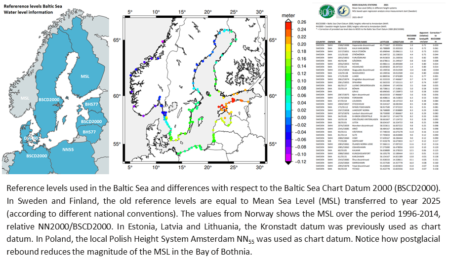
Mean sea level and difference to the old reference datum relative BSCD2000 (pdf, png) currently varies from a few cm at the entrance to maximally approximately 25 cm in the middle of the Baltic Sea.
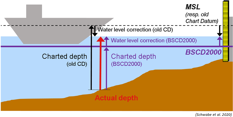
The important message is: The actual water depth does not change! Although charted depths may change and appear lower, even by some decimeters, the corrections for the current water level change accordingly.
Contact information
Further reading
- International Hydrographic Review Article – The Baltic Sea Chart Datum 2000 (IHR, 2020, Publication P-1, pp. 63-83)
- International Hydrographic Review Note – Release note for the BSCD2000 height transformation grid (IHR, 2023, vol. 29, no. 2, pp. 194-199)
- IHO GI Registry Vertical Datum
- IHO GI Registry Baltic Sea Chart Datum 2000 (BSCD2000)
- CDWCWG Brief description of the Baltic Sea Chart Datum 2000 (BSCD2000)
- CDWCWG Specification of the Baltic Sea Chart Datum 2000 (BSCD2000)
- CDWCWG Baltic Sea Chart Datum 2000 (BSCD2000)
Additional information
Country-specific information by the BSHC member states: DE, DK, SE, FI, EE, LV, LT, PL
Further information on national geoid models: DE#1, DE#2, DK, NO, SE, FI, EE, LV, LT, PL
Further information on national geodetic reference: see bottom of page
Download of the BSCD2000 height transformation grid
Download link (realization 2023, first release: November 2023)
[ZIP]
The download package contains the BSCD2000 height transformation grid for use in ship navigation, hydrographic surveying, offshore construction, etc., in combination with real-time GNSS positioning, ENC and water level corrections. Also provided are versions of the gravimetric quasigeoid for scientific use in geodesy and ocean science (e.g. altimetry).
Grid formats include ASCII (TXT), GeoTiff and GTX. All grids are geo-referenced to ETRS89 geographical coordinates (EPSG:4258). The bounding box of the grid nodes is 8.5° – 31° E / 51.0° – 66.5° N and the grid spacing is 0.02° in longitude by 0.01° in latitude. ASCII format has columns longitude, latitude, grid value.
Please see file README.txt in the download package for detailed description of the grids.
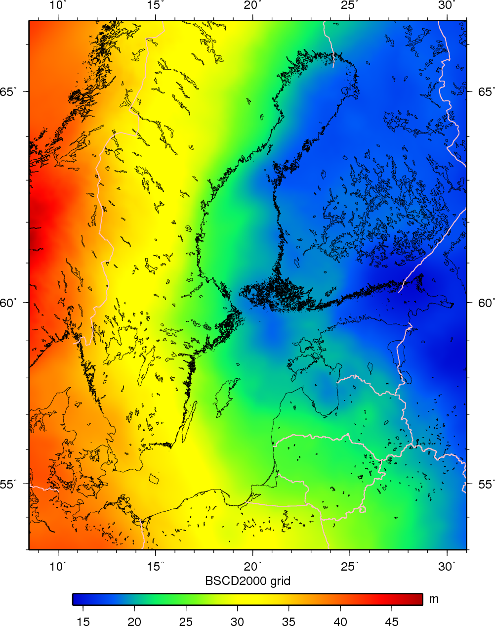
Figure: The seamless BSCD2000 height transformation grid.
Citation
Schwabe, J., Varbla, S., Ågren, J., Teitsson, H., Ellmann, A., Liebsch, G., Forsberg, R., Strykowski, G., Bilker-Koivula, M., Liepins, I., Parseliunas, E., Keller, K., Omang, O., Vestøl, O., Kaminskis, J., Wilde-Piorko, M., Pyrchla, K., Somla, J., Westfeld, P., Hammarklint, T. (2023): The Baltic Sea Chart Datum 2000 height transformation grid (Realization 2023). DOI https://doi.org/10.58440/iho-bscd2000
Liebsch, G., Schwabe, J., Varbla, S., Ågren, J., Teitsson, H., Ellmann, A., Forsberg, R., Strykowski, G., Bilker-Koivula, M., Liepiņš, I., Paršeliūnas, E., Keller, K., Vestol, O., Omang, O., Kaminskis, J., Wilde-Piórko, M., Pyrchla, K., Olsson, P., Förste, C., Ince, E.S., Somla, J., Westfeld, P. and Hammarklint, T. (2023): Release Note for the BSCD2000 height transformation grid. International Hydrographic Review (29) 2, 194-199, DOI https://doi.org/10.58440/ihr-29-2-n11
Important remarks
- Bicubic interpolation is required for maximum consistency with national geoid models (see item 5).
- BSCD2000 defines a standard uncertainty of 5 cm or better for the vertical component. BSCD2000 is realized by the national geodetic height systems and coordinates on land which agree with the BSCD2000 definition at the level of typically 1-2 cm (standard deviation). In the nautical maps, ENCs, water readings, etc., this is shown by the annotation BSCD2000RH2000 (Sweden), BSCD2000DHHN2016 (Germany), etc.
- Thus, the BSCD2000 height correction grid was fitted to agree with the national coordinates and heights on land (and, thus, reference heights for harbor readings) with the same level of accuracy. For exceptions in Denmark see item 8.
- Consequently, the BSCD2000 height correction grid is not an equipotential surface but a transformation surface with absorbs all remaining errors, inconsistencies and systematic differences in the reference system and the data. For example, ETRS89 coordinates have a different convention for the permanent tide effect (tide-free) compared to most national height systems (typically “zero-tide” or “mean tide”), leading to an apparent latitudinal trend.
- In order to provide a smooth transition between land and sea for coastal applications, the BSCD2000 height correction grid has also been designed to reproduce the current national geoid models on land, as far as possible. To this end, the national geoid models were first blended along the land borders (also in the coastal zone), and then blended with the marine geoid model for BSCD2000 in a transition zone 10 km off the coastline. For exceptions in Denmark see item 8. Resampling from national geoid models to the BSCD2000 grid domain, where needed, was done by bicubic interpolation (applies to DE, DK, NO, FI and LV only).
- This means that:
– On land, resampling differences up to 3 millimeters (up to 15 mm in the mountain areas of Norway) can occur between the BSCD2000 grid and some national geoid models.
– Due to the harmonization, differences up to several centimeters can occur between the BSCD2000 grid and the national geoid models in a transition zone of 10 km to both sides of the land borders. This also applies in the 10 km coastal zone, but here the largest differences between the harmonized BSCD2000 grid and the national geoid models only seldomly exceed 3 cm. Typically, the differences remain within 1-2 cm. In the offshore areas, change from the national geoid models (where defined) to the BSCD2000 grid may be larger due to the considerably improved marine geoid. See detailed plots for specific countries. - For pure land applications, the national geoid models should be used where possible. In offshore areas (more than 10 km distance from the coast), the new BSCD2000 grid should be used. In the transition zone (10 km distance from the coast), the BSCD2000 grid is generally recommended.
- Heights on the Danish islands Bornholm, Ærø, Samsø, Anholt and Læsø, although subsumed under the national height datum DVR90, are in fact related to local height datums. These are not included in the BSCD2000 grid, i.e., the BSCD2000 grid approximates the mean DVR90 level of the adjacent Danish mainland. Differences between the BSCD2000 grid and the national geoid model DVR90(2023) around the islands are shown in the detailed plots. Mean height offsets (local height minus BSCD2000 from comparison at benchmarks) are:
Bornholm –13 cm (between –15 cm and –11 cm at 5 benchmarks)
Ærø –3 cm (1 benchmark)
Samsø +4 cm (2 benchmarks)
Anholt –3 cm (2 benchmarks)
Læsø –1 cm (1 benchmark)
Further information on national geodetic reference
Poland
Information about ASG-EUPOS GNSS reference stations:
https://www.asgeupos.pl/index.php?wpg_type=syst_descr&sub=ref_st
GNSS RINEX download site:
https://system.asgeupos.pl/ Levelling data for Poland available as WFS service:
http://mapy.geoportal.gov.pl/wss/service/PZGIK/PodstawowaOsnowaGeodezyjnaWysokosciowa